The purpose of this document is to provide scientists using the Thermal Emission Imaging System (THEMIS) Visible and
Infrared special geometry products with enough information to enable
them to read and understand the data products.
Topics discussed in this document include an introduction to the ISIS
software used to geometrically project the images, a description of the
processing algorithm used to generate the images, a description of the data
product format, and the contents of available ancillary labels and files.
THEMIS geometry products (IR-GEO and
VIS-GEO) are spatially registered, spectral image CUBEs derived from the THEMIS
calibrated radiance products (IR-RDR and VIS-RDR). Each image file is accompanied by a detached
ASCII label describing the data format, contents, and processing history. THEMIS derived geometry products (IR-PBT and IR-DCS)
are spatially registered, image products generated from the IR-GEO products.
For
additional information, the user is referred to the following documents
available in the THEMIS archive, unless otherwise noted:
1.
Calibration Report for the Thermal Emission
Imaging System (THEMIS) for the 2001 Mars Odyssey Mission, P.R. Christensen.
2.
Mars Odyssey THEMIS: Archive SIS.
3.
Mars Odyssey THEMIS: Data Processing User’s
Guide, P.R. Christensen.
4.
Mars Odyssey THEMIS Geometry Processing with ISIS, J. Torson, internet
documentation:
http://isis.astrogeology.usgs.gov/Isis2/isis-bin/themis-processing.cgi.
5.
Mars Odyssey THEMIS: Standard Data Products SIS.
6.
Overview of ISIS Architecture, internet documentation:
http://isis.astrogeology.usgs.gov/Isis2/isis-bin/isis_arch.cgi.
7.
Planetary Data System Data Standards Reference,
October 30, 2002, Version 3.5, JPL D-7669, Part 2.
8.
The Thermal Emission Imaging System (THEMIS) for
the Mars 2001 Odyssey Mission,
P.R. Christensen, et. Al., Space Science
Review, Vol. 110, pp 85-130, 2004.
9.
Edwards, C. S., K. J. Nowicki, P. R.
Christensen, J. Hill, N. Gorelick, and K. Murray (2011), Mosaicking of global
planetary image datasets: 1. Techniques and data processing for Thermal
Emission Imaging System (THEMIS) multi-spectral data, J. Geophys. Res.,
116(E10), E10008, doi:10010.11029/12010JE003755.
10. Edwards,
C. S., P. R. Christensen, and J. Hill (2011), Mosaicking of global planetary
image datasets: 2. Modeling of wind streak thicknesses observed in Thermal
Emission Imaging System (THEMIS) daytime and nighttime infrared data, J.
Geophys. Res., 116, E10005, doi:10.1029/2011JE003857.
1.2 ISIS Overview
ISIS (Integrated System for Imagers and
Spectrometers) is a specialized image processing software package developed by
the Astrogeology Program of the United States Geological Survey (USGS, Flagstaff Arizona). The software package includes the standard
tools desired for the digital processing of multi-spectral image datasets, as
well as instrument specific tools to convert between raw camera geometry and
standardized map coordinate systems. Cartographic
conversions are made possible by incorporating spacecraft and camera models
into the ISIS software. The software and complete documentation is
available for download from the ISIS website:
http://isis.astrogeology.usgs.gov.
The ISIS
software manipulates and stores image data in multi-dimensional qube files,
formatted similar to the standard Planetary Data System (PDS) QUBE data object
[7]. Each qube file is composed of an
ASCII label attached to one or more data objects, such as a HISTORY object and
the qube data object. A
three-dimensional qube file, with two spatial dimensions and one spectral
dimension, is referred to specifically as an ISIS CUBE file. A complete description of ISIS
qube files can be found in Overview of
ISIS Architecture [6].
Several essential tools have been developed
to allow the ISIS software to process and
geometrically project THEMIS standard data products. First, the ISIS
software was given the ability to ingest the THEMIS QUBE data products. Although the PDS QUBE and ISIS CUBE formats
are similar, they are different enough to require a translation tool. Second, the conversion parameters between the
raw raster coordinate systems of the THEMIS cameras and a standardized Mars
coordinate system were used to define several specialized projection tools. The projection capability is facilitated with
the geometry information in Mars Odyssey SPICE kernels available from NAIF (http://naif.jpl.nasa.gov/naif). All aspects of the ISIS-THEMIS tools are
discussed in Mars Odyssey THEMIS Geometry
Processing with ISIS [4].
1.3 THEMIS Overview
The THEMIS instrument is a combined infrared
(IR) and visible (VIS) multi-spectral
pushbroom imager. The imaging system is comprised of a three-mirror, off-axis,
reflecting telescope in a rugged enclosure, a visible/infrared beamsplitter, a
silicon focal plane for visible detection, and a microbolometer for infrared detection. The telescope has a 12-cm effective aperture,
speed of f/1.6, and co-aligned VIS-IR detector arrays. A major feature of this instrument is the
uncooled IR microbolometer array which can be operated at ambient
temperature. A small thermal electric
(TE) cooler is used to stabilize the detector temperature to ±0.001 K. The calibration flag is the only moving part
in the instrument, allowing for thermal calibration and protection of the
detectors from unintentional direct Sun illumination when the instrument is not
in use.
THEMIS IR images are acquired at selectable
image lengths and in combinations of ten selectable bands. The image width is 320 pixels (32 km, based
on the nominal 400 km mapping orbit) and the length is variable, in multiples
of 256 line increments, with a minimum and maximum image lengths of 272 and
65,296 lines respectively (27.2 km and 6,530 km, based on the nominal mapping
orbit). The IR focal plane is covered by
ten ~1 µm-bandwidth strip filters (Table 1a), producing ten band images with
bands 1 and 2 having the same wavelength range.
THEMIS VIS images are
acquired in framelets of size 1024 pixels crosstrack by 192 lines downtrack,
for a total image size of 3.734 Mbytes or less.
The number of framelets is determined by the number of bands selected
(five available, Table 1b) and the spatial resolution selected (three summing
modes available). The size of an image is given by:
[((1024
* 192) * #framelets * #bands) ¸
summing2] ≤ 3.734
Mbytes
For example, if spatial summing is not
applied (summing=1), either a single-band, 19-framelet (65.6 km) image or a
5-band 3-framelet (10.3 km) image can be collected. Each VIS
image collected is stored in the THEMIS internal buffer and must be transferred
to the spacecraft computer before a subsequent image can be acquired. VIS images may be compressed with one of two
available compression algorithms before storage on the spacecraft computer.
VIS images can be acquired simultaneously
with IR images, but the spacecraft can only transfer data from one of the two
THEMIS imagers at a time. The IR imager
transfers data as it is being collected, while the VIS images are stored within
an internal THEMIS buffer for later transfer to the spacecraft computer. Before storage of IR images on the spacecraft,
one or more data reduction techniques may be selected. The time-delay integration (TDI) algorithm
may be applied to improve the signal-to-noise ratio of each pixel by co-adding
16 independent measurements of each point on the ground. Lossless data compression may be applied to
the image by the hardware Rice algorithm chip.
Tables 1a&b: THEMIS available bands
|
INFRARED
BANDS
|
|
VISIBLE
BANDS
|
|
Band
Numbers
|
Center (mm)
|
FWHM
(mm)
|
|
Band
Numbers
|
Center (mm)
|
FWHM
(mm)
|
|
IR-1
|
6.78
|
1.01
|
|
V-1
|
0.425
|
0.049
|
|
IR-2
|
6.78
|
1.01
|
|
V-2
|
0.540
|
0.051
|
|
IR-3
|
7.93
|
1.09
|
|
V-3
|
0.654
|
0.053
|
|
IR-4
|
8.56
|
1.16
|
|
V-4
|
0.749
|
0.053
|
|
IR-5
|
9.35
|
1.20
|
|
V-5
|
0.860
|
0.045
|
|
IR-6
|
10.21
|
1.10
|
|
|
|
|
|
IR-7
|
11.04
|
1.19
|
|
|
|
|
|
IR-8
|
11.79
|
1.07
|
|
|
|
|
|
IR-9
|
12.57
|
0.81
|
|
|
|
|
|
IR-10
|
14.88
|
0.87
|
|
|
|
|
The IR and VIS
cameras share the instrument optics and housing, but have independent power and
data interfaces to the spacecraft. In Spring 2006, a software patch was loaded into
the spacecraft memory to apply spatial summing to IR images before
downlink; use of this patch decreases
the effective bandwidth of the IR camera, and allows for the collection of
additional IR images. Final data stream
formatting for both the IR and VIS data is
performed by the spacecraft processor.
Further information about onboard processing is available in the THEMIS Space Science Review paper [8].
THEMIS standard data products include experimental, reduced, and calibrated data
files. The experimental and reduced
products (VIS-EDR, IR-EDR, VIS-RDR, and IR-RDR) are
spectral image QUBEs containing one layer per each visible or infrared band
collected. The calibrated products (VIS-ABR
and IR-BTR) are one band IMAGE files produced from the reduced data
products. A detailed description of the
format and content for each of the standard data products is provided in the THEMIS Standard Data Products SIS [5].
The THM-RDR data products are uncompressed,
binary, band-sequential QUBEs of 16-bit integer data. The image width is fixed (320 pixels for IR,
1024 pixels for VIS), but the length varies
proportional to the duration of the observation. Calibration algorithms used to generate each
THM-RDR are described in the THEMIS Data
Processing User’s Guide [3] and each execution adds an entry in the
cumulative HISTORY object contained in the ASCII header of the QUBE. The THM-RDR QUBE images are not spatially
registered, and bands (layers) within a single image can be out of registration
with each other by up to 10 lines and/or columns.
The THEMIS geometric data products will be
generated by the staff at the ASU Mars Space Flight Facility and be distributed
in conjunction with their standard data product counterparts. Geometric projection of the IR-RDR and VIS-RDR
standard data products may be augmented with additional manipulation of the images,
which may invalidate the calibrated radiance values inherited from the source
RDR product. Geometric data products
will be stored as one projection per image in a multispectral ISIS CUBE
file. All processing performed on the GEO
cube will be recorded in the HISTORY object of the detached PDS label.
THEMIS derived geometric data products
(IR-PBT and IR-DCS) are generated by additional processing of the IR-GEO
products. The IR-PBT products are one
band IMAGE files, which conform to the same format standards as the IR-BTR
products. The IR-DCS products are stored
as simple PNG image products, similar to the PDS standard BROWSE images.
2. gEOMETRIC pROCESSING
In order to generate the geometric
projections from the calibrated radiance images, the THEMIS RDR.QUBE format
must be modified so that it can be ingested into the standard ISIS
projection software. The ISIS THM2ISIS tool is used to convert the PDS formatted IR-RDR
or VIS-RDR image into an LEV-CUBE image that can be manipulated by subsequent ISIS software tools.
At this time the label is initialized with geometric parameters, but the
data values and image dimensions remain fundamentally unchanged.
When necessary, the default behavior of THM2ISIS can be modified for an
image. The most common change is the
selection of the kernels which define the orientation of the spacecraft during the acquisition of each image; the kernels used are specified in the
ISIS_GEOMETRY object. The PDS2ISIS and
LEVINIT HISTORY objects are generated during THM2ISIS processing.
The generation of infrared projected images
(IR-GEO) includes multiple processing steps. First, a post-calibration filter
is applied to the infrared calibrated radiance images (IR-RDR). Next, these modified radiance images are ingested
into ISIS (Section 2.1) and the geometric
projection products are completed by projecting the image into standard Mars
coordinates. Finally, additional image
processing is applied to complete the process.
These IR-GEO products contain geometrically
registered and atmospherically corrected calibrated radiance, making them ideal
for use in surface studies and for use with other projected Mars datasets. For these purposes, two derived products may
be generated from the geometric projection with further processing: a projected
brightness temperature product (IR-PBT), and a decorrelation stretch product
(IR-DCS). Parameters of each process,
applied by default or request, are recorded in the label of the final product
as “keyword = values” pairs (see section 3.3);
some significant label entries are highlighted throughout this section
using [ ].
The ISIS THMIRMC
tool is used to project the ISIS formatted
modified IR-RDR data into a geometrically registered image cube. This tool translates the radiance values into
the desired map projection by applying a bilinear interpolation algorithm
[DNINTERP = “BILINEAR”, GEOM object], which incorporates the values of the four
pixels closest to each mapped position.
The spatial transformation is performed following the projection parameters
defined for each image based on the conditions shown in Table 2.2.
Table 2.2: IR-GEO Map parameters
|
Map Parameter
|
Value
|
Application Conditions
|
|
kmres
|
0.1
km/pix
|
SPATIAL_SUMMING = 1
|
|
lonsys
|
180
|
CENTER_LONGITUDE < 2 or
CENTER_LONGITUDE > 358
|
|
|
360
|
2 < CENTER_LONGITUDE < 358
|
|
mappars
|
SINU:lon,OCENTRIC
(where lon = default center longitude)
|
-70 < LATITUDE < 70
|
|
|
POLA:+90,0
|
LATITUDE > 60
|
|
|
POLA:-90,0
|
LATITUDE < -60
|
Unless otherwise noted, the infrared
geometry product generated by these parameters is identified
IooooonnnGGG.CUB.gz (see Section 3.1), where the value of “GGG” is the
projection abbreviation.
Additional image processing may be applied
to the IR-GEO image cube either before or after the ISIS
projection steps. Each process described
in this section generates a HISTORY object in the detached PDS label (see
Section 3.4.3), as shown in Appendix A.5.
The UDDW
(Undrift and Dewobble) filter is applied to the IR-RDR QUBE before the image is
projected, and is designed to correct for time-dependent signal offsets which
are highly correlated in the original image coordinates. It removes undesirable data value fluctuations
resulting from changes in the temperature of the IR detector array during image
collection. This filter alters the
calibrated radiance values of bands 1 - 9 (where available), but does not
change the radiance values of band 10.
The RECTIFY
algorithm is applied to the projected infrared image to minimize the null space
around the image and to prepare the data for additional processing. The image data is first rotated to align the
top line of the projected image with the horizontal edge (x axis) of the image
frame; then each image line is shifted left
to align with the vertical edge (y axis) of the image frame. This process may result in spatial
distortions that are reversible using the parameters provided in the RECTIFY HISTORY object and the RECONSTITUTE algorithm.
The DEPLAID
algorithm applies a specialized, high-pass filter to projected and rectified
infrared radiance images. These filters
attempt to remove the effects of both column and row correlated, band
independent noise that would otherwise dominate a decorrelation stretch
image. The noise originates from voltage
fluctuations in the THEMIS instrument during image collection; this noise is minimized, but not completely
removed, during the IR-RDR calibration DESTRIPE
process (see THEMIS: Data Processing
User’s Guide [3]). Validation of the
results of this algorithm confirm that the average spectra from a 50 x 50 pixel
sample area remains unchanged.
The ARADCOR
(Automated RADiance CORrection) algorithm attempts to remove the atmospheric
radiance component from the projected and filtered infrared image. The correction value is based on multiple 50
x 50 pixel samples identified throughout the image which meet several temperature
and quality criteria.
Projected Brightness Temperature (PBT)
images are available as the projected equivalent product of the standard IR-BTR
images. To generate an IR-PBT product,
the brightness temperature algorithm described in THEMIS: Data Processing User’s Guide [3], Section 2.2.11 is applied
to the projected and rectified IR-GEO product.
Then the resulting image is restored to the full projection dimensions
using the RECONSTITUTE algorithm for
ease of viewing. The IR-PBT products are
available as standard PDS IMGAGE objects, almost identical to the IR-BTR
products; the only differences being
that several of the important parameters from the IR-GEO History objects are
available as keywords in the IR-PBT label (see Appendix A.2).
The decorrelation stretch (DCS) method
maximizes the differences between bands in order to highlight the compositional
information in the image. THEMIS IR-DCS products
provide a quick preview of the potential compositional variation available in an
infrared image. They are generated from
the IR-GEO images with an average surface temperature greater than 220 K and a
minimum of eight bands (bands 3-10 required).
To generate an IR-DCS image, two final noise
filters are applied to all available bands, then the DCS algorithm is applied,
and the results are saved as a simple image (PNG format). First, any residual uncorrelated noise is
removed by applying the DESTREAK and WHITE_NOISE algorithms. These filters are useful for reducing the anomalous
noise in the qualitative DCS image, but are not appropriate for application on
a quantitative radiance product. Next, three
bands of the radiance image are selected for decorrelation and displayed in
color as variations of red, green, and blue. The THEMIS IR-DCS images are executed on three
standard RGB band combinations: bands 6, 4, and 2; bands 8, 7, and 5; and bands
9, 6, and 4. The results are made
available individually in full projection dimensions (using RECONSTITUTE), and also available combined together side-by-side in rectified
dimensions with a brightness temperature image for contrast (see Section 3.1).
The infrared geometric projections are
generated from the calibrated radiance images (IR-RDR) by: (1) modifying the
THEMIS RDR QUBE format so that it can be ingested into the standard ISIS projection software; (2) projecting the image with
standardized parameters. Depending on
the specification of the image, additional image processing may be applied
before and/or after the image is projected.
2.4.1 THM2ISIS
The ISIS THM2ISIS tool is used to convert the PDS formatted image IR-RDR
QUBE into an ISIS formatted LEV-CUBE image that can be manipulated by
subsequent ISIS software tools. At this time the label is initialized with
geometric parameters, however the data values and dimensions remain
fundamentally unchanged.
When necessary, the default behavior of THM2ISIS is modified for an image; parameters applied by default or request are
recorded in the label and history objects of the final projected image (see section 3.3). The kernels used to define the orientation of
the spacecraft during each image
acquisition are specified in the ISIS_GEOMETRY object. The PDS2ISIS and LEVINIT HISTORY objects are
generated during the THM2ISIS processing
2.4.2 Pre-projection
Processing
UDDW
2.4.3 THMIRMC
2.4.4 Post-projection
Processing
Deplaid
DCS
After the visible calibrated radiance images
(VIS-RDR) are ingested into ISIS (Section 2.1), the geometric projection products are completed by
projecting the image into standard Mars coordinates, and then applying any
additional image processing. Parameters
of each process, applied by default or request, are recorded in the label of
the final projected image as “keyword = values” pairs (see section 3.3); some significant label entries are
highlighted throughout this section using [ ].
2.5.1 THMVISMC
The ISIS THMVISMC
tool is used to project the ISIS formatted
VIS-RDR data into a geometrically registered image cube. The spatial transformation is performed
following the parameters defined for each image. Individual visible framelets are projected
independently then mosaicked together per band, with the overlapping pixels
taking the value of the downtrack framelets [TOP = “YES”]. Calibrated radiance values are translated
into the desired map projection by applying a bilinear interpolation algorithm
[DNINTERP = “BILINEAR”, GEOM object], which incorporates the values of the four
pixels closest to each mapped position.
The map parameters used to project each visible
image are determined by the conditions shown in Table 2.3. Unless otherwise noted, the visible geometry
product generated by these parameters is identified VooooonnnLOC.CUB (see
Section 3.1), where the abbreviation “LOC” recognizes that this is a local-latitude
appropriate projection.
Table 2.5: VIS-GEO Local map parameters
|
Map Parameter
|
Value
|
Application Conditions
|
|
kmres
|
0.018
km/pix
|
SPATIAL_SUMMING = 1
|
|
|
0.036 km/pix
|
SPATIAL_SUMMING = 2
|
|
|
0.072 km/pix
|
SPATIAL_SUMMING = 4
|
|
lonsys
|
180
|
CENTER_LONGITUDE < 2 or
CENTER_LONGITUDE > 358
|
|
|
360
|
2 < CENTER_LONGITUDE < 358
|
|
mappars
|
SINU:lon,OCENTRIC
(where lon = default center longitude)
|
-60 < LATITUDE < 60
|
|
|
POLA:+90,lon
(where lon = meridian longitude)
|
LATITUDE > 60
|
|
|
POLA:-90,lon
(where lon = meridian longitude)
|
LATITUDE < -60
|
2.5.2 Additional Processing
Additional image processing may be applied
to the VIS-GEO projected image cube. Each
process described in this section generates a HISTORY object in the detached
PDS label (see Section 3.4.3), as shown in Appendix A.5.
The DESPECKLE
process is a cosmetic correction applied to selected VIS-RDR QUBEs before the
image is projected. On occasion,
temporary radiation disruptions in the camera electronics produce anomalously
bright or dark pixels scattered throughout the image. The distribution and intensity of this pixel
“speckling” varies between each radiation event, but the corrupt pixels are
usually concentrated either along the framelet edges, or within the more saturated
areas of the image. This algorithm
identifies the corrupt pixels based on an image specific DN threshold [THRESHOLD_VALUE
= # ], and then replaces it with a value matching the average of the surrounding
valid pixels. This process alters the
calibrated radiance values of the selected pixels in the corrected bands.
The COFF
(Cosmetically Optimized Flat-Field) process is applied to maintain the overall
radiance level of each framelet in the VIS-GEO image. This is accomplished by removing an optimized
flat-field from each framelet before the THMVISMC
projection. When applied, all source
VIS-RDR radiance values are significantly modified.
The FEATHER
process is applied to cosmetically enhance the discontinuities along the
overlapping framelet boundaries of a projected visible image. This cosmetic filter is applied in concert
with the THMVISMC projection of the
visible framelets of each band, before they are mosaicked together into the
final cube file. Because of the nature
of this algorithm, all values in the resulting projected image may have been
significantly modified from the source VIS-RDR calibrated radiance values.
Each THEMIS geometry image product is named using the
THEMIS standard data product naming convention, which follows the pattern “AooooonnnGGG.EXT”. As established in the standard documentation,
the PRODUCT_ID pattern is defined as
A is
a 1-letter description of the type of image collected; [ V = visible image; I =
infrared image ]
ooooo is
a 5-digit mission orbit number when the image was collected; [ 01000 = mapping orbit number example ]
nnn is a 3-digit image sequence number
indicating the order that images were collected each orbit; [ 001 = first image collected in the xxxxx
orbit ]
The suffix-extension “GGG.EXT”
value identifies the geometry product type and the file format standards (see
Section 3.3). The combinations used with
the THEMIS geometry products are
D###.PNG identifies a single, full projection IR-DCS browse image, where
the numeric value lists the IR bands represented in red, green, and blue
respectively
DCS.PNG identifies a multiple panel IR-DCS browse
image, composed of the following side-by-side, rectified images: D875, D964,
D642 (if available), and brightness temperature
LOC.CUB identifies
the VIS-GEO data product: a local-latitude appropriate projection, stored in a
multi-spectral ISIS image cube
LOC.LBL identifies the PDS detached label file for
a VIS-GEO data product
PBT.IMG identifies the IR-PBT data product; both data
and label information are available in this file
POL.CUB identifies
an IR-GEO data product: a polar projection, stored in a multi-spectral ISIS image cube
POL.LBL identifies the PDS detached label file for
an IR-GEO data product
SNU.CUB identifies
an IR-GEO data product: a sinusoidal projection, stored in a multi-spectral ISIS image cube
SNU.LBL identifies the PDS detached label file for
an IR-GEO data product
3.1.2 Revision Conventions
As with the THEMIS standard data products, a revision to
the geometry product after the initial public release may be warranted. At that time, the PRODUCT_VERSION_ID keyword
in the product label will be incremented, an ERRATA_ID will be established, and
the change made will be documented. The
ERRATA_ID will take the form ODTxx_rrrr_v.v, where xx is the image and dataset
abbreviation, rrrr is the original RELEASE_ID number, and v.v is the
PRODUCT_VERSION_ID value. Each revision
will be documented in the label HISTORY object, the ERRATA.TXT and the
appropriate release catalog (ODTIGREL.CAT or ODTIVGREL.CAT), and by modifying
records as necessary in the indexes (INDEX_ODTxx, THMIDX_IR, or
THMIDX_VIS). See Appendix A.3 for label
keyword definitions and the THEMIS Archive SIS [2]
for document specifications.
3.2 Standards Used in Generating Geometry
Products
The THEMIS GEO CUBE products are similar to Planetary Data
System QUBE data product in file format and label structure, however, they are
not intended to meet all of the standards specified in the PDS Standards
Reference [7]. The detached label
associated with each image CUBE does comply with Planetary Data System
standards for file labels. The THEMIS
geometric products are NASA processing Level 2 images, derived from the THM-RDR
products (Level-1A) and adjusted for instrument location, pointing, and
sampling.
3.2.2 Time Standards
All time stamps stored in the GEO label are extracted from
the source THM-RDR image; a full
description of the time standards used with THEMIS data products is available
in the THEMIS
Standard Data Products SIS [5], Section 2.3.4.
The time stamp (SPACECRAFT_CLOCK_START_COUNT) stored with
each geometry product is the value of the spacecraft clock at the time of data
acquisition of the leading edge of the first detector in the array (filter 1),
even if filter 1 is not downlinked. For
visible images, this time is calculated from the UNCORRECTED_SCLK_START_COUNT
and may differ by as much as 4 seconds, depending on which bands are acquired
in the observation. The stop time stamp,
SPACECRAFT_CLOCK_STOP_COUNT, is calculated from the sum of the UNCORRECTED_SCLK_START_COUNT and
IMAGE_DURATION. Depending on which bands
are acquired in a visible image, the difference of the start and stop time
stamps may not be equivalent to IMAGE_DURATION.
All geometric values are based on Mars IAU 2000
areocentric model with east positive longitude.
The geographic map projection for each data product is identified in the
MAP_PROJECTION_TYPE keyword (see Appendices A.1-3) in both labels and defined
in detail in the ISIS attached cube label.
ISIS requires the precise
geometric locations of the Odyssey spacecraft, THEMIS camera, and Mars in order
to correctly project each image. This
information is referenced from the Mars Odyssey SPICE kernels published by the
navigation team (http://naif.jpl.nasa.gov/naif), and the kernels actually used
are recorded in the label of the ISIS CUBE.
The Planet and Instrument kernels are static, and only the current
version is used. The Spacecraft and Camera-matrix
kernels are time dependant, constructed from measurements made by the
spacecraft; the kernel corresponding to
the image acquisition time is used. The
camera-matrix kernels contain intermittent time gaps which occasionally overlap
with the imaging times; when this
happens, a substitute kernel is used which assumes a known and fixed
camera-matrix geometry.
Due to the potential for large file sizes, many THEMIS GEO
products are routinely compressed using the GZIP utility. The “.gz” extension on any product filename
(see Section 3.1.3 above) indicates that the gzip compression has been
applied. For more information, or to
download this free software, visit http://www.gzip.org.
The THEMIS geometry images maintain the ISIS CUBE format
of the software from which they were generated [6]. Each CUBE is composed of an ASCII label
attached to a core of uncompressed, binary, band-sequential qubes of scaled, 16-bit integer data.
Like the unprojected equivalent IR-BTR images, the THEMIS
IR-PBT images are PDS standard IMAGE objects.
See Section 2.3.3 of the THEMIS Standard Data Products SIS [5] for a description of
this THEMIS file format.
3.3.1 ISIS CUBE
Data Object
The CUBE core is an array of sample values
in three dimensions: two spatial dimensions (samples and lines) and one
spectral dimension (bands), as shown conceptually in Figure 1a. Additional information may be stored in
“suffix” planes (back, side, or bottom) as shown in Figure 1b. This format allows each CUBE to be
simultaneously a set of images (at different wavelengths) of the same target
area, and also a multi-point spectrum at each spatially registered pixel in the
target area. The spectral dimension of
each THM-GEO cube is identical to the source THM-RDR image, but the spatial
dimensions are expanded to accommodate the projected data.
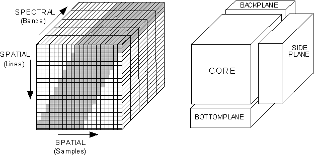
Figure 1a: ISIS
CUBE core structure with Figure
1b. Exploded view of ISIS CUBE
projected data pixels shown in
gray
The
data format of the THM-GEO CUBE is similar to the source THM-RDR QUBE, and both
are stored as floating point values, scaled into 16-bit integers. To recover the floating point values, apply
the following function to each data value per band (xi)
y = m x + b
x + b
where m is the CORE_MULTIPLIER value and b
is the CORE_BASE value, given in the CUBE label.
additional comment on pixel resampling??
Missing image pixels and padding around the image
data to square up the spatial dimensions are set to the CORE_NULL value. The total count of missing lines in an IR-GEO
image is stored in the MISSING_SCAN_LINES keyword of the detached label.
3.3.2 ISIS CUBE Label Object
The CUBE object has an
attached label containing pertinent observation information, and header data
objects (Figure 2). A “keyword=value” text format, similar to the structure of
the PDS Object Definition Language (ODL), define the CUBE structure, the CORE and
suffix parameters, the geographic projection parameters, and the ISIS History. See the Overview
of ISIS Architecture [7] for examples of the elements in this label.
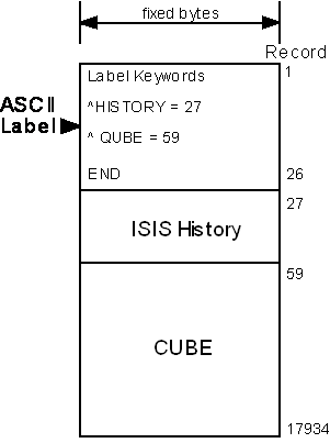
Figure 2: Example of a ISIS CUBE: attached label,
header data object, and image data
3.4 GEO Label Format
A PDS label describes the structure, content, and
observation specifications of the data.
It is a discrete ASCII text available with each image file. Information in the label is stored in a
“keyword=value” text format and structured in the Object Definition Language
(ODL) of PDS. Example labels are shown
in Appendices A.1-A.2; individual
keyword items are defined in Appendices A.3.
The first lines of the label are the file identification
keywords and associated values. Next are the file structure keywords, which
define the number and size of records in the associated ISIS CUBE data file. The pointer keywords define the filename and start
byte of the HISTORY (in the PDS label) and the header and image data objects in
the ISIS CUBE file. Finally,
“identification data elements” define parameters of the mission, spacecraft,
instrument team, and data stream. See
Appendix A.3 for a detailed description of these keywords.
3.4.2 QUBE Object Label
The QUBE object keywords are organized by the following
sub-structure descriptions:
QUBE structure - parameters of the
multidimensional array (image)
CORE description - parameters of the array
elements (pixels)
Observation parameters - operational modes
of the instrument for this image
Band-bins -
parameters of the layers (bands) in the array
See
Appendix A.3 for a detailed description of the keywords used in the QUBE label.
A cumulative HISTORY object is available in
each geometry label. The history object structure keywords
define the size and format of the data object stored later in the label. The
HISTORY object itself is a structured series of text entries identifying all
previous computer manipulations of the data in the file; the format is not
intended to be compliant with PDS-ODL standards. HISTORY entries may include identification of
source data, processes performed, processing parameters, and dates and times of
processing. See Appendix A.5 for a
detailed description of the entries and keywords used with THM-GEO HISTORY
objects.
3.5 Data Product Archive
The special geometry data products will be generated
and validated at the ASU Mars Space Flight Facility. The size of individual geometry products
depends on several factors: image type (VIS
vs. IR), length of an image, number of bands in the image, and map projection. Within these parameters, most VIS-GEO images will
be a factor of 1-4 larger than the source VIS-RDR, and
most IR-GEO images will be a factor of X larger than the source IR-RDR.
Validation will be conducted using the latest, best-effort algorithms
available.
Standard data products will be archived and
released following the agreement outlined in the THEMIS Archive SIS [2]. Starting in January
2006, the special geometry data products will be released concurrent
with their source THM-RDR images;
geometry products for previously
released THM-RDR images will be added to the archive as available. Due to the large volume of data products
expected from the mission, physical copies will be made for PDS long-term
archive purposes only. All other data
distribution will be facilitated through an online THEMIS data archive service,
maintained by the ASU Mars Space Flight Facility.
4. Applicable Software
The THEMIS team uses the software tools DAVINCI and ISIS
to generate, display, and analyze the THM-RDR and THM-GEO images. DAVINCI is a data analysis package for
working with multispectral images.
DAVINCI is distributed by ASU and is available at
http://davinici.asu.edu/software. ISIS
is an image processing package produced by USGS - Flagstaff and is available at http://isis.astrogeology.usgs.gov.
Since THEMIS
images are stored and labeled using a standard and known structure, any
tool that can be taught to understand that structure should be able to view
them.
IDL/Envi – Archview - ??
A. Appendicies
Appendices A.1-3 contain example labels from THEMIS IR-GEO,
THEMIS IR-PBT, and VIS-GEO, with definitions of individual label keywords given
in Appendix A.4. “Valid values” for each
item are shown in [ ] at end of each description, as appropriate. Appendix A.5 contains definitions for the
basic HISTORY keywords and example geometric HISTORY objects. Appendix A.6 contains geometric parameter fields
available in the THEMIS indexes.
Appendix A.7 describes the geometric quality assessment and associated
HISTORY object.
A.1 Example Label: IR-GEO
An example IR-GEO label is shown below:
PDS_VERSION_ID
= PDS3
/*
File Identification and Structure */
RECORD_TYPE
= "FIXED_LENGTH"
RECORD_BYTES
= 512
FILE_RECORDS
= 8922
/*
Pointers to Data Objects */
^HISTORY
= 3480 <BYTES>
^HEADER
= ("I31099044SNU.CUB")
^QUBE
= ("I31099044SNU.CUB", 67 )
/*
Identification Data Elements */
MISSION_NAME
= "2001 MARS ODYSSEY"
INSTRUMENT_HOST_NAME
= "2001 MARS ODYSSEY"
INSTRUMENT_NAME
= "THERMAL EMISSION IMAGING SYSTEM"
INSTRUMENT_ID
= "THEMIS"
DETECTOR_ID
= "IR"
MISSION_PHASE_NAME
= "EXTENDED-3"
SPACECRAFT_ORIENTATION_DESC = (PITCH,
ROLL, YAW)
SPACECRAFT_ORIENTATION = (0, 0, 0)
SPACECRAFT_POINTING_MODE =
"NADIR"
^SPACECRAFT_POINTING_MODE_DESC =
"ODY_ORIENT_POINT.TXT"
TARGET_NAME
= "MARS"
PRODUCT_ID
= "I31099044SNU"
PRODUCER_ID
= "ODY_THM_TEAM"
DATA_SET_ID
= "ODY-M-THM-5-IRGEO-V1.0"
PRODUCT_CREATION_TIME
= 2009-03-25T17:41:41
PRODUCT_VERSION_ID
= "1.0"
SOURCE_PRODUCT_VERSION_ID
= "1.0"
RELEASE_ID
= "0028"
START_TIME
= 2008-12-18T00:44:50.791
STOP_TIME
= 2008-12-18T00:44:59.858
SPACECRAFT_CLOCK_START_COUNT
= "914028697.153"
SPACECRAFT_CLOCK_STOP_COUNT
= "914028706.170"
START_TIME_ET
= 282833156.000
STOP_TIME_ET
= 282833165.000
ORBIT_NUMBER
= 31099
/*
History Object Structure */
OBJECT
= HISTORY
BYTES = 7615
HISTORY_TYPE = CUSTOM
INTERCHANGE_FORMAT = ASCII
END_OBJECT
= HISTORY
OBJECT
= QUBE
/* QUBE Structure */
AXES = 3
AXIS_NAME = (SAMPLE, LINE, BAND)
/* Core Description */
CORE_ITEMS = (352,321,10)
CORE_NAME =
"CALIBRATED_SPECTRAL_RADIANCE"
CORE_ITEM_BYTES = 4
CORE_ITEM_TYPE = PC_REAL
CORE_BASE = 0.000000e+00
CORE_MULTIPLIER = 1.000000e+00
CORE_UNIT =
"WATT*CM**-2*SR**-1*UM**-1"
CORE_NULL = -32768
CORE_VALID_MINIMUM = -32752
CORE_LOW_REPR_SATURATION = -32767
CORE_LOW_INSTR_SATURATION = -32766
CORE_HIGH_REPR_SATURATION = -32765
CORE_HIGH_INSTR_SATURATION = -32764
/* Suffix Description */
SUFFIX_ITEMS = (1,0,0)
SUFFIX_BYTES = 4
SAMPLE_SUFFIX_NAME = RECTIFY_LEFTEDGE
SAMPLE_SUFFIX_ITEM_BYTES = 4
SAMPLE_SUFFIX_ITEM_TYPE = LSB_INTEGER
SAMPLE_SUFFIX_BASE = 0.000000
SAMPLE_SUFFIX_MULTIPLIER = 1.000000
SAMPLE_SUFFIX_VALID_MINIMUM = 16#FF7FFFFA#
SAMPLE_SUFFIX_NULL = 16#FF7FFFFB#
SAMPLE_SUFFIX_LOW_REPR_SAT = 16#FF7FFFFC#
SAMPLE_SUFFIX_LOW_INSTR_SAT = 16#FF7FFFFD#
SAMPLE_SUFFIX_HIGH_REPR_SAT = 16#FF7FFFFF#
SAMPLE_SUFFIX_HIGH_INSTR_SAT = 16#FF7FFFFE#
/* Observation Parameters */
FLIGHT_SOFTWARE_VERSION_ID =
"1.00"
COMMAND_SEQUENCE_NUMBER = 31099
IMAGE_ID = 44
DESCRIPTION = "35 deg day atmos"
INST_CMPRS_RATIO = 2.72
UNCORRECTED_SCLK_START_COUNT =
"914028697.153"
IMAGE_DURATION = 9.067
GAIN_NUMBER = 16
OFFSET_NUMBER = 2
TIME_DELAY_INTEGRATION_FLAG = "ENABLED"
RICE_FLAG = "ENABLED"
SPATIAL_SUMMING = 1
PARTIAL_SUM_LINES = "N/A"
MISSING_SCAN_LINES = 0
MD5_CHECKSUM =
"ed9c27074865056d8d5f1edcfb2737a8"
/* Band Bins */
GROUP = BAND_BIN
BAND_BIN_FILTER_NUMBER = (1, 2, 3, 4,
5, 6, 7, 8, 9, 10)
BAND_BIN_BAND_NUMBER = (1, 2, 3, 4, 5,
6, 7, 8, 9, 10)
BAND_BIN_CENTER = (6.78, 6.78, 7.93,
8.56, 9.35, 10.21, 11.04,
11.79, 12.57, 14.88)
BAND_BIN_WIDTH = (1.01, 1.01, 1.09,
1.16, 1.20, 1.10, 1.19,
1.07, 0.81, 0.87)
BAND_BIN_UNIT = "MICROMETER"
END_GROUP = BAND_BIN
END_OBJECT
= QUBE
END
A.2 Example Label: IR-PBT
An example IR-PBT label is shown below:
PDS_VERSION_ID
= PDS3
FILE_NAME
= "I33413035PBT.IMG"
RECORD_TYPE
= "FIXED_LENGTH"
RECORD_BYTES
= 419
FILE_RECORDS
= 336
LABEL_RECORDS
= 6
^IMAGE
= 7
MISSION_NAME
= "2001 MARS ODYSSEY"
INSTRUMENT_HOST_NAME
= "2001 MARS ODYSSEY"
INSTRUMENT_NAME
= "THERMAL EMISSION IMAGING SYSTEM"
INSTRUMENT_ID
= "THEMIS"
DETECTOR_ID
= "IR"
MISSION_PHASE_NAME
= "EXTENDED-3"
SPACECRAFT_ORIENTATION_DESC
= (PITCH, ROLL, YAW)
SPACECRAFT_ORIENTATION
= (0,-20,0)
SPACECRAFT_POINTING_MODE
= "HGA_MITIGATION_R-20"
^SPACECRAFT_POINTING_MODE_DESC
= "ODY_ORIENT_POINT.TXT"
TARGET_NAME
= "MARS"
PRODUCT_ID
= "I33413035PBT"
PRODUCER_ID
= "ODY_THM_TEAM"
DATA_SET_ID
= "ODY-M-THM-5-IRPBT-V1.0"
PRODUCT_CREATION_TIME
= 2009-07-07T20:28:08
PRODUCT_VERSION_ID
= "1.0"
SOURCE_PRODUCT_VERSION_ID
= "1.0"
RELEASE_ID
= "0028"
START_TIME
= 2009-06-26T13:39:06.870
STOP_TIME
= 2009-06-26T13:39:15.936
SPACECRAFT_CLOCK_START_COUNT
= "930491180.025"
SPACECRAFT_CLOCK_STOP_COUNT
= "930491189.042"
START_TIME_ET
= 299295613.1
STOP_TIME_ET
= 299295622.1
UNCORRECTED_SCLK_START_COUNT
= "930491180.025"
IMAGE_DURATION
= 9.067
ORBIT_NUMBER
= 33413
BAND_NUMBER
= 9
BAND_CENTER
= 12.57 <MICROMETERS>
SPATIAL_SUMMING
= 1
GEOMETRY_SOURCE_DESC
= "Reconstructed"
PDS2ISIS_VERSION
= "2004-05-28"
GEOM_VERSION
= "2004-06-17"
CUBEIT_VERSION
= "2004-06-17"
LONGITUDE_SYSTEM
= 360
MINIMUM_LATITUDE
= 70.3685
MAXIMUM_LATITUDE
= 70.905
CENTER_LONGITUDE
= 55
WESTERNMOST_LONGITUDE
= 53.408
EASTERNMOST_LONGITUDE
= 55.5926
MAP_RESOLUTION
= 592.747
MAP_SCALE
= 0.1
MAP_PROJECTION_TYPE
= "SINUSOIDAL"
PROJECTION_LATITUDE_TYPE
= "PLANETOCENTRIC"
LINE_PROJECTION_OFFSET
= -42028.5
SAMPLE_PROJECTION_OFFSET
= -317.5
ASU_PROCESSES
= "PROJECT; RECTIFY; RECONSTITUTE"
MINIMUM_BRIGHTNESS_TEMPERATURE
= 152.701
MAXIMUM_BRIGHTNESS_TEMPERATURE
= 163.601
OBJECT
= IMAGE
LINES = 330
LINE_SAMPLES = 419
SAMPLE_TYPE = UNSIGNED_INTEGER
SAMPLE_BITS = 8
SAMPLE_NAME =
"BRIGHTNESS_TEMPERATURE"
SAMPLE_UNIT = K
NULL_CONSTANT = 0
OFFSET = 152.701
SCALING_FACTOR = 0.042744
MD5_CHECKSUM =
"dea37efdfefd89e7195171bf33c3dbc5"
END_OBJECT
= IMAGE
END
(add page break before A.2)
A.3 Example Label: VIS-GEO
An example VIS-GEO label is shown below:
/*
File Identification and Structure */
/*
Pointers to Data Objects */
^HISTORY = 4131 <BYTES>
^HEADER = ("V01001004.loc.cub")
^QUBE = ("V01001004.loc.cub", 59 )
/*
Identification Data Elements */
SPACECRAFT_ORIENTATION_DESC = (PITCH,
ROLL, YAW)
SPACECRAFT_ORIENTATION = (0, 0, 0)
SPACECRAFT_POINTING_MODE =
"NADIR"
^SPACECRAFT_POINTING_MODE_DESC =
"ODY_ORIENT_POINT.TXT"
/*
History Object Structure */
/*
QUBE Structure */
/*
Core Description */
/*
Observation Parameters */
/*Band
Bins */
A.4 Label Keyword Descriptions
FILE AND DATA IDENTIFICATION ELEMENTS
PDS_VERSION_ID
PDS version number for the label
format. [PDS3]
RECORD_TYPE
Style of records in this label file. [“FIXED_LENGTH”]
RECORD_BYTES
Number of bytes per record in ISIS
CUBE file.
FILE_RECORDS
Number of records in ISIS CUBE file,
including labels and data.
LABEL_RECORDS
Number of records used for label data; value does not include records in the
Telemetry table or HISTORY object.
Pointer to HISTORY
Start byte location of HISTORY
object in this detached THM-GEO label; units given in < >.
Pointer to HEADER
Filename and start byte location of
the ISIS CUBE label object; byte =1 is implied if no byte location is given.
Pointer to IMAGE
Start byte location of the image
data object.
Pointer to QUBE
Filename and start byte location of
the ISIS CUBE data object.
MISSION_NAME
Name of the mission including the
THEMIS instrument. [“2001 MARS ODYSSEY”]
INSTRUMENT_HOST_NAME
Name of the host spacecraft for the
THEMIS instrument. [“2001 MARS ODYSSEY”]
INSTRUMENT_NAME
Proper name of the instrument.
[“THERMAL EMISSION IMAGING SYSTEM”]
INSTRUMENT_ID
Abbreviated name of instrument used
to collect this image. [“THEMIS”]
DETECTOR_ID
Abbreviated name of camera used to
collect this image. [“IR” or “VIS”]
MISSION_PHASE_NAME
Mission
phase during which this image was collected.
[“MAPPING”, “EXTENDED-1”]
SPACECRAFT_ORIENTATION_DESC
Description of rotation axis
corresponding to values of SPACECRAFT_ORIENTATION keyword. [(PITCH,ROLL,YAW)]
SPACECRAFT_ORIENTATION
Odyssey orientation during which
this image was collected; described as a angle (in degrees) of rotation away
from nadir around the three axes spacecraft frame of reference; see given in
SPACECRAFT_POINTING_MODE_DESC value for more information. [(#,#,#)]
SPACECRAFT_POINTING_MODE
Description of the Odyssey pointing
mode during which this image was collected;
see text given in SPACECRAFT_POINTING_MODE_DESC value for definitions of
valid modes.
^SPACECRAFT_POINTING_MODE_DESC
Pointer to text file describing
valid Odyssey orientation values and pointing modes; text file is in the
DOCUMENT directory.
[“ODY_ORIENT_POINT.TXT”]
TARGET_NAME
The name of the target observed in
the image. [“MARS”]
PRODUCT_ID
Unique identifier for this THM-GEO
image. [“Aooooonnnggg”]
PRODUCER_ID
Identity of the producer of this dataset. [“ODY_THM_TEAM”]
DATA_SET_ID
Unique alphanumeric identifier of
this dataset. [“ODY-M-THM-5-IRGEO-V1.0”,
“ODY-M-THM-5-VISGEO-V1.0”]
PRODUCT_CREATION_TIME
Time of creation of this QUBE on the
ground (in UTC). [yyyy-mm-ddThh:mm:ss]
PRODUCT_VERSION_ID
Version
identification of this THM-GEO image.
SOURCE_PRODUCT_VERSION_ID
Version identification of the THM-RDR
QUBE from which this product was derived.
RELEASE_ID
Identification of the original
public release of this THM-GEO image.
START_TIME
The time of data acquisition of the
leading edge of the detector array (filter 1), even if filter 1 is not
downlinked; the difference of STOP_TIME
minus START_TIME may not be equivalent to IMAGE_DURATION. Value given in spacecraft event time (SCET),
UTC format. [yyyy-mm-ddThh:mm:ss.fff]
STOP_TIME
The time of the end of data
acquisition calculated from the sum of the UNCORRECTED_SCLK_START_COUNT and
IMAGE_DURATION; given in spacecraft event time (SCET), UTC format. [yyyy-mm-ddThh:mm:ss.fff]
SPACECRAFT_CLOCK_START_COUNT
The value of the spacecraft clock at
the time of data acquisition of the leading edge of the detector array (filter
1), even if filter 1 is not downlinked;
the difference of SPACECRAFT_CLOCK_STOP_COUNT minus SPACECRAFT_CLOCK_START_COUNT may not be
equivalent to IMAGE_DURATION. Value
given in seconds.
SPACECRAFT_CLOCK_STOP_COUNT
The time on the spacecraft clock at
the end of data acquisition (in seconds) calculated from the sum of the
UNCORRECTED_SCLK_START_COUNT and IMAGE_DURATION.
START_TIME_ET
The time of data acquisition of the
leading edge of the detector array (filter 1), even if filter 1 is not
downlinked; the difference of
STOP_TIME_ET minus START_TIME_ET may not be equivalent to IMAGE_DURATION. Value given in spacecraft event time (SCET),
ET format.
STOP_TIME_ET
The time of the end of data
acquisition calculated from the sum of the UNCORRECTED_SCLK_START_COUNT and
IMAGE_DURATION; given in spacecraft event time (SCET), ET format.
ORBIT_NUMBER
Spacecraft orbit during which this
image was observed.
HISTORY STRUCTURE
See Appendix A.5
QUBE STRUCTURE & CORE DESCRIPTION
AXES
Number of dimensions (axes) of the
QUBE. [3]
AXIS_NAME
Names of axes in physical storage
order. [(SAMPLE, LINE, BAND)]
CORE_ITEMS
The length of each of the three axes
of the core in pixels.
CORE_NAME
Name of the data value stored in
core of ISIS CUBE.
[“CALIBRATED_SPECTRAL_RADIANCE”]
CORE_ITEM_BYTES
Core element size in bytes. [2]
CORE_ITEM_TYPE
Core element type. [MSB_INTEGER]
CORE_BASE
The offset value of the stored data;
the CORE_BASE value is added to the scaled data (see CORE_MULTIPLIER) to
reproduce the true data.
CORE_MULTIPLIER
The constant value by which the
stored data is multiplied to produce the scaled data; the CORE_BASE value is
added to the scaled data to reproduce the true data.
CORE_UNIT
Unit of the value stored in the core
of QUBE. [ “WATT*CM**-2*SR**-1*UM**-1”]
CORE_NULL
Value assigned to missing data and
padding of projected image.
CORE_VALID_MINIMUM
Value of the minimum valid core data
in an RDR QUBE.
CORE_LOW_REPR_SATURATION
Value of representation saturation
at the low end in an RDR QUBE.
CORE_LOW_INSTR_SATURATION
Value of instrument saturation at
the low end in an RDR QUBE.
CORE_HIGH_REPR_SATURATION
Value of representation saturation
at the high end in an RDR QUBE.
CORE_HIGH_INSTR_SATURATION
Value of instrument saturation at
the high end in an RDR QUBE.
SUFFIX DESCRIPTION (IR-GEO QUBEs only)
SUFFIX_ITEMS
The dimensions of available suffix
planes following the order given in AXIS_NAME keyword. [(1, 1, 0)]
SUFFIX_BYTES
The allocation in bytes of each
suffix plane defined. [4]
AXIS_SUFFIX_NAME
Name of “axis” suffix plane, where
“axis” can be either SAMPLE or LINE in IRRDR QUBEs. [HORIZONAL_DESTRIPE (for SAMPLE suffix
planes) or VERTICAL_DESTRIPE (for LINE suffix planes)]
AXIS_SUFFIX_ITEM_BYTES
Size of “axis” suffix plane elements
in bytes, where “axis” can be either SAMPLE or LINE in IRRDR QUBEs. [2]
AXIS_SUFFIX_ITEM_TYPE
“Axis” suffix plane element type,
where “axis” can be either SAMPLE or LINE in IRRDR QUBEs. [LSB_INTEGER]
AXIS_SUFFIX_BASE
Base value of “axis” suffix plane
item scaling, where “axis” can be either SAMPLE or LINE in IRRDR QUBEs.
AXIS_SUFFIX_MULTIPLIER
Multiplier for “axis” suffix plane
item scaling, where “axis” can be either SAMPLE or LINE in IRRDR QUBEs.
AXIS_SUFFIX
_VALID_MINIMUM
Value of the minimum valid “axis”
suffix plane data, where “axis” can be either SAMPLE or LINE in IRRDR
QUBEs. [16#FF7FFFFA#]
AXIS_SUFFIX _NULL
Value assigned to “invalid” or
missing data in an “axis” suffix plane, where “axis” can be either SAMPLE or
LINE in IRRDR QUBEs. [16#FF7FFFFB#]
AXIS_SUFFIX
_LOW_REPR_SATURATION
Value of representation saturation
at the low end in an “axis” suffix plane, where “axis” can be either SAMPLE or
LINE in IRRDR QUBEs. [16#FF7FFFFC#]
AXIS_SUFFIX
_LOW_INSTR_SATURATION
Value of instrument saturation at
the low end in an “axis” suffix plane, where “axis” can be either SAMPLE or
LINE in IRRDR QUBEs. [16#FF7FFFFD#]
AXIS_SUFFIX
_HIGH_REPR_SATURATION
Value of representation saturation
at the high end in an “axis” suffix plane, where “axis” can be either SAMPLE or
LINE in IRRDR QUBEs. [16#FF7FFFFF#]
AXIS_SUFFIX
_HIGH_INSTR_SATURATION
Value of instrument saturation at
the high end in an “axis” suffix plane, where “axis” can be either SAMPLE or
LINE in IRRDR QUBEs. [16#FF7FFFFE#]
SUFFIX DESCRIPTION
SUFFIX_ITEMS
The dimensions of available suffix planes
following the order given in AXIS_NAME keyword.
[(1, 1, 0)]
SUFFIX_BYTES
The allocation in bytes of each suffix plane
defined. [4]
AXIS_SUFFIX_NAME
Name of “axis” suffix plane, where “axis” can
be either SAMPLE or LINE in IRRDR QUBEs.
[HORIZONAL_DESTRIPE (for SAMPLE suffix planes) or VERTICAL_DESTRIPE (for
LINE suffix planes)]
AXIS_SUFFIX_ITEM_BYTES
Size of “axis” suffix plane elements in
bytes, where “axis” can be either SAMPLE or LINE in IRRDR QUBEs. [2]
AXIS_SUFFIX_ITEM_TYPE
“Axis” suffix plane element type, where
“axis” can be either SAMPLE or LINE in IRRDR QUBEs. [MSB_INTEGER]
AXIS_SUFFIX_BASE
Base value of “axis” suffix plane item
scaling, where “axis” can be either SAMPLE or LINE in IRRDR QUBEs.
AXIS_SUFFIX_MULTIPLIER
Multiplier for “axis” suffix plane item
scaling, where “axis” can be either SAMPLE or LINE in IRRDR QUBEs.
AXIS_SUFFIX
_VALID_MINIMUM
Value of the minimum valid “axis” suffix
plane data, where “axis” can be either SAMPLE or LINE in IRRDR QUBEs. [16#FF7FFFFA#]
AXIS_SUFFIX
_NULL
Value assigned to “invalid” or missing data
in an “axis” suffix plane, where “axis” can be either SAMPLE or LINE in IRRDR
QUBEs. [16#FF7FFFFB#]
AXIS_SUFFIX
_LOW_REPR_SATURATION
Value of representation saturation at the low
end in an “axis” suffix plane, where “axis” can be either SAMPLE or LINE in
IRRDR QUBEs. [16#FF7FFFFC#]
AXIS_SUFFIX
_LOW_INSTR_SATURATION
Value of instrument saturation at the low end
in an “axis” suffix plane, where “axis” can be either SAMPLE or LINE in IRRDR
QUBEs. [16#FF7FFFFD#]
AXIS_SUFFIX
_HIGH_REPR_SATURATION
Value of representation saturation at the
high end in an “axis” suffix plane, where “axis” can be either SAMPLE or LINE
in IRRDR QUBEs. [16#FF7FFFFF#]
AXIS_SUFFIX
_HIGH_INSTR_SATURATION
Value of instrument saturation at the high
end in an “axis” suffix plane, where “axis” can be either SAMPLE or LINE in
IRRDR QUBEs. [16#FF7FFFFE#]
OBSERVATION PARAMETERS
FLIGHT_SOFTWARE_VERSION_ID
Indicates version of instrument
flight software used to acquire image.
[“1.00”]
COMMAND_SEQUENCE_NUMBER
Numeric identifier for the sequence
of commands sent to the spacecraft which include this image.
IMAGE_ID
Numeric identifier for this image
within the onboard command sequence.
DESCRIPTION
Description of image written by
mission planner.
INST_CMPRS_RATIO
The ratio of the size, in bytes, of the uncompressed data file to the
compressed data file.
UNCORRECTED_SCLK_START_COUNT
The spacecraft clock value (in
seconds) when the instrument was commanded to acquire an observation.
This can differ from the SPACECRAFT_CLOCK_START_COUNT (or the other
START_TIME keywords) by as much as 4 seconds, depending on which bands are
acquired in the image.
IMAGE_DURATION
The length of time (in seconds)
required to collect all frames of all bands in the downlinked image.
INST_CMPRS_NAME
The type of compression applied to
the VIS data and removed before storage in the
image QUBE. [“NONE” or “DCT” or
“PREDICTIVE”]
FOCAL_PLANE TEMPERATURE
Temperature in Kelvin of the VIS camera focal plane array at the time of the
observation.
EXPOSURE_DURATION
The length of time the VIS detector array is exposed per frame in an image;
given in milliseconds.
INTERFRAME_DELAY
The time between successive frames
of a VIS image; given in seconds.
SPATIAL_SUMMING
Onboard spatial average of NxN set
of pixels, where N is the value of the keyword.
SPATIAL_SUMMING = 1 implies that no spatial averaging has been applied
to the image. [VIS: 1 or 2 or 4; IR: 1
through 320]
PARTIAL_SUM_LINES
The number of lines in a summed IR
image which were produced by averaging less than N lines of the original
non-summed image, where N is the value of the SPATIAL_SUMMING keyword. [“N/A”
for spatial_summing=1 or integer for spatial_summing > 1]
MISSING_SCAN_LINES
The total number of scan lines
missing from an IR image when it was received at Earth.
GAIN_NUMBER
The gain value of the THEMIS IR
camera; a multiplicative factor used in the analog to digital conversion.
OFFSET_NUMBER
The offset value of the THEMIS IR
camera; the offset value multiplied by a constant voltage is added to the
measured voltage in the analog to digital conversion.
TIME_DELAY_INTEGRATION_FLAG
Status of onboard algorithm which
applies a temporal average of successive lines in an IR image; when enabled,
THEMIS TDI averages 16 detector rows to equal one line in an IR image. [“ENABLED” or “DISABLED”]
MISSING_SCAN_LINES
The total number of scan lines
missing from an IR image when it was received at Earth.
MD5_CHECKSUM
A 128-bit checksum identification of
the data portion of the QUBE. Corruption
of the data QUBE will result in a different value when the MD5 algorithm is
reapplied as compared to the value stored in the keyword. An example of the source code applied by ASU
is available in SRC/BIN/md5_qube.pl. A
complete definition of the MD5 algorithm is available at
http://www.ietf.org/rfc/rfc1321.txt.
[“fd2781d05bdc0215dc87a0f41035ad77”]
BAND-BINS or BAND INFORMATION
BAND_NUMBER
Identifies from which band in the
source RDR this image was derived; see
Table 1, Section 2.2 of this document (THM-SDPSIS).
BAND_BIN_FILTER_NUMBER
List of filter numbers corresponding
to each layer (band) contained in the image; up to 10 entries possible for IR
images and up to 5 entries possible for VIS
images. The filter number describes the
physical location of the band in the detector array; filter 1 is on the leading edge of the
detector array.
BAND_BIN _BAND_NUMBER
List of band numbers corresponding
to each layer (band) contained in the image; up to 10 entries possible for IR
images and up to 5 entries possible for VIS
images. The band number is equivalent to
the instrument band number listed in Table 1, Section 2.2 of this document
(THM-SDPSIS).
BAND_CENTER
The wavelength value of the band
contained in the image; units are given
in < > with the value.
BAND_BIN_CENTER
List of wavelength values
corresponding to each layer (band) contained in the image; up to 10 entries
possible for IR images and up to 5 entries possible for VIS
images.
BAND_BIN_WIDTH
Calculated full width, half maximum
(in micrometers) for each band listed in the
BAND_BIN_ BAND_NUMBER.
BAND_BIN_UNIT
Unit which applies to the values of
the BAND_BIN_CENTER keyword.
[“MICROMETER”]
IMAGE STRUCTURE & GEOMETRIC PARAMTERS
(IMAGEs only)
GEOMETRY_SOURCE_DESC
Description of the geometry kernels
used by the ISIS software when generating
geometric information for this image.
[“Not Available”, “Predicted”, “Reconstructed”, “Nadir pointing assumed”,
or “Off Nadir pointing assumed”]
PDS2ISIS_VERSION
Version of ISIS
software algorithm PDS2ISIS used during the projection of this image
[“yyyy-mm-dd”].
GEOM_VERSION
Version of ISIS
software algorithm GEOM used during the projection of this image
[“yyyy-mm-dd”].
CUBEIT_VERSION
Version of ISIS
software algorithm CUBEIT used during the projection of this image [“yyyy-mm-dd”].
LONGITUDE_SYSTEM
Longitude system standards in place
during the projection of this image, where a value of 180 indicates that longitude
is measured from 0 to +180 east of the meridian and 0 to -180 west of the
meridian; a value of 360 indicates that longitude is measured from 0 to 360
degrees from the meridian in the positive longitude direction.
MINIMUM_LATITUDE
The northernmost latitude on the
planet Mars of the image.
MAXIMUM_LATITUDE
The southernmost latitude on the
planet Mars of the image.
CENTER_LONGITUDE
Approximate longitude on the planet
Mars at the image center.
WESTERNMOST_LONGITUDE
The longitude on the planet Mars at
the image western edge.
EASTERNMOST_LONGITUDE
The longitude on the planet Mars at
the image eastern edge.
MAP_RESOLUTION
The scale of the image in pixels per
degree.
MAP_SCALE
The scale of the image in kilometers
per pixel.
MAP_PROJECTION_TYPE
The type of projection applied to
this image [ “SINUSOIDAL” ].
PROJECTION_LATITUDE_TYPE
The type of latitude that is sample
in equal increments by successive image lines [“PLANETOCENTRIC” ].
LINE_PROJECTION_OFFSET
The line offset value between the
map projection origin and the upper left corner of the image.
SAMPLE_PROJECTION_OFFSET
The sample offset value between the
map projection origin and the upper left corner of the image.
ASU_PROCESSES
Simple list identifying the ASU processes
that have been applied to this image; a more complete description of these
processes may be available in the Appendix A.5 examples.
RECTIFY_WIDTH
Parameter of the ASU Rectify process
which describes the original width of the projected image.
RECTIFY_ANGLE
Parameter of the ASU Rectify process
which describes the amount of rotation required to make the top line of a
projected image parallel to the x-axis of the image.
MAXIMUM_BRIGHTNESS_TEMPERATURE
Maximum brightness temperature value
measured within the image.
MINIMUM_BRIGHTNESS_TEMPERATURE
Minimum brightness temperature value
measured within the image.
LINES
Total number of data pixels along
the vertical axis of the image.
LINE_SAMPLES
Total number of data pixels along
the horizontal axis of the image.
SAMPLE_TYPE
Data storage representation of a
pixel value [ UNSIGNED_INTEGER ]
SAMPLE_BITS
Stored number of bits in a single
pixel value.
SAMPLE_NAME
Identifies
the scientific meaning of each pixel value ["BRIGHTNESS_TEMPERATURE"
] .
SAMPLE_UNIT
Identifies the scientific unit of
each pixel value [ K ].
NULL_CONSTANT
Numeric value used to represent NULL
data.
OFFSET
The offset value of the stored data;
the offset value is added to the scaled data to reproduce the true data.
SCALING_FACTOR
The constant value by which the
stored data is multiplied to produce the scaled data; the offset value is added
to the scaled data to reproduce the true data.
BAND_BIN_BASE
The
offset value for the stored data of each band listed in the
BAND_BIN_BAND_NUMBER. The BAND_BIN_BASE
value is added to the scaled data (see BAND_BIN_MULTIPLIER) to reproduce the
true data.
BAND_BIN_MULTIPLIER
The
constant value by which the stored data of each band listed in the
BAND_BIN_BAND_NUMBER is multiplied to produce the scaled data; the
BAND_BIN_BASE value is added to the scaled data to reproduce the true data.
A.5 HISTORY Object Items and Examples
The HISTORY data object is
described within the THM-GEO labels by the following keywords:
BYTES
Number
of bytes in the HISTORY object.
HISTORY_TYPE
Identifies the software compliance
of the HISTORY object format. [CUSTOM]
INTERCHANGE_FORMAT
Identifies the manner in which the
HISTORY object data items are stored.
[ASCII]
Each program that operates on the
data product will generate a new “history entry” and will concatenate the new
entry onto the existing HISTORY object.
All HISTORY objects follow this basic format, where the values have been
replaced with keyword descriptions:
GROUP = The
name of the program that generated the history entry.
DATE_TIME = Date and time, in
UTC standard format, that the program was executed. [yyyy-mm-ddThh:mm:ss]
SOFTWARE_DESC = Program generated description
and execution notes.
VERSION_ID = Program version
number.
USER_NAME = Username and name of
computer. [“marvin@mars”]
USER_NOTE = User supplied brief
description of program; may be blank.
GROUP = Used
to delineate the statements specifying the parameters of the program; will not be present if additional keywords
are not required. [PARAMETERS]
KEYWORD = Value.
END_GROUP = [PARAMETERS]
END_GROUP =
The name of the program that generated the history entry.
END
THM-GEO
labels contain the cumulative processing history of the observation. The HISTORY objects generated during THEMIS
standard data processing (THM-EDR, THM-RDR, THM-BTR, or THM-ABR) are described
in Appendix 8 of the THEMIS Standard Data Products SIS [5]. Examples of the HISTORY objects added during
geometric processing are shown below.
ISIS
PROJECTION HISTORY OBJECT
GROUP =
ISIS_PROJECTION
DATE_TIME
= 2004-12-07T13:28:26
SOFTWARE_DESC =
"ISIS geometric projection of a THEMIS
QUBE.
Process
includes translation of file formats (PDS2ISIS and LEVINIT); determining the
valid core data range (DSK2DSK); geometric transformation of image planes
(GEOM); and merging the individual bands back together (MOSAIC and CUBEIT). See header of resulting ISIS
cube for more details of projection.
The
ISIS_COMMAND parameter may also include additional processing steps that are
described in other HISTORY groups in this label."
VERSION_ID
= "2003-07-23T23:51:07-7"
USER_NAME
= "marvin@mars"
USER_NOTE
= ""
GROUP
= PARAMETERS
GEOMETRY_SOURCE_DESC =
"Reconstructed"
ISIS_COMMAND =
"feather.dv V010XXRDR/V01001002RDR.QUB \
SINU:315,OCENTRIC
0.018 --"
PDS2ISIS_VERSION = "
2003-06-17"
GEOM_VERSION =
"1995-06-16"
MOSAIC_VERSION = "
2003-07-01"
LONGITUDE_SYSTEM = 360
MINIMUM_LATITUDE = -9.0765104
MAXIMUM_LATITUDE = -8.0947313
CENTER_LONGITUDE = 315.0000000
WESTERNMOST_LONGITUDE =
315.2828979
EASTERNMOST_LONGITUDE =
315.7157593
MAP_RESOLUTION = 3293.0387513
MAP_SCALE = 0.0180000
MAP_PROJECTION_TYPE =
"SINUSOIDAL_EQUAL-AREA"
PROJECTION_LATITUDE_TYPE =
"PLANETOCENTRIC"
LINE_PROJECTION_OFFSET =
26656.000000
SAMPLE_PROJECTION_OFFSET =
920.000000
END_GROUP
= PARAMETERS
END_GROUP
= ISIS_PROJECTION
IR-GEO UDDW HISTORY OBJECT
GROUP
= ASU_PROCESS_UDDW
DATE_TIME =
2009-03-25T17:41:41
SOFTWARE_DESC =
"The Undrift-Dewobble filter was applied to this THEMIS IR-RDR QUBE to
remove data value fluctuations caused by changes in the temperature of the IR
detector array. Band 10 values remain
unchanged."
VERSION_ID = 1.80
USER_NAME =
"thmproc@c145.mars.asu.edu"
END_GROUP
= ASU_PROCESS_UDDW
IR-GEO RECTIFY HISTORY OBJECT
GROUP
= ASU_PROCESS_RECTIFY
DATE_TIME = 2008-12-31T2hh:mm:ss
SOFTWARE_DESC =
"The Rectify algorithm was applied to this THEMIS IR-GEO cube to minimize
null space around the image data and to prepare the data for the Deplaid
algorithm. This process may result in
spatial distortions that are reversible using the parameters provided."
VERSION_ID = 2005.07
USER_NAME =
"thmproc@c145.mars.asu.edu"
USER_NOTE = ""
GROUP = PARAMETERS
WIDTH = 385.000000
ANGLE = 3.084812
END_GROUP = PARAMETERS
END_GROUP
= ASU_PROCESS_RECTIFY
IR-GEO DEPLAID HISTORY OBJECT
GROUP
= ASU_PROCESS_DEPLAID
DATE_TIME = 2008-12-31T3hh:mm:ss
SOFTWARE_DESC =
" Deplaid is a specialized, high-pass filter which was applied to remove
row and line radiance spikes from the THEMIS IR-RDR data in this projection.
Validation of the resulting spectral image confirms that the average spectra
from a 50 x 50 pixel sample area remains unchanged."
VERSION_ID = 2005.07
USER_NAME =
"thmproc@c145.mars.asu.edu"
USER_NOTE = ""
END_GROUP
= ASU_PROCESS_DEPLAID
IR-GEO Auto-RADCOR HISTORY OBJECT
GROUP
= ASU_PROCESS_ARADCOR
DATE_TIME = 2008-12-31T3hh:mm:ss
SOFTWARE_DESC = "An automated radiance correction
algorithm was applied to the THEMIS IR-RDR data in this projection to remove
the atmospheric radiance component. The
correction value is based on multiple 50 x 50 pixel samples located throughout
the image which meet several temperature and emissivity criteria."
VERSION_ID = 2005.07
USER_NAME =
"thmproc@c145.mars.asu.edu"
USER_NOTE = ""
END_GROUP
= ASU_PROCESS_DCS
VIS-GEO DESPECKLE HISTORY OBJECT
GROUP = ASU_PROCESS_DESPECKLE
DATE_TIME = 2012-07-01Thh:mm:ss
SOFTWARE_DESC =
"The Despeckle filter was applied after calibration of this THEMIS VIS-RDR
QUBE. This cosmetic filter uses the
method below to identify anomalously bright (or dark) pixels; all values from
the original RDR exceeding the threshold value have been replaced. The replacement value is calculated by
filtering the surrounding good pixels."
VERSION_ID = 1.0
USER_NAME =
"smith@mars"
USER_NOTE =
""
GROUP = PARAMETERS
METHOD =
"STANDARD DEVIATION"
METHOD_LIMIT =
# or ( #, #, #, #, # )
FILTER = "filter
name”
FILTER_SIZE = #
THRESHOLD_VALUE
= # or ( #, #, #, #, # )
END_GROUP =
PARAMETERS
END_GROUP = ASU_PROCESS_DESPECKLE
IR-GEO
UDDW HISTORY OBJECT
IR-GEO
DCS HISTORY OBJECT
VIS-GEO COFF HISTORY OBJECT
GROUP =
ASU_PROCESS_COFF
DATE_TIME
= 2005-08-19T17:00:
SOFTWARE_DESC =
"The radiance values of this THEMIS VIS-RDR QUBE were modified before
geometric projection. This is a cosmetic
correction which removes an optimized flat-field from each framelet in the
image. The process maintains the overall
radiance level of each framelet at the expense of significantly modifying the
source VIS-RDR radiance values"
VERSION_ID
= 2005.07
USER_NAME
= "smith@mars"
USER_NOTE
= ""
GROUP
= PARAMETERS
FLATFIELD_FILE =
"/themis/data/flat_frames12.prof1.fits"
FLATFIELD_FILE_DATE =
2005-03-16T04:54:55
END_GROUP
= PARAMETERS
END_GROUP =
ASU_PROCESS_COFF
VIS-GEO FEATHER HISTORY OBJECT
GROUP =
ASU_PROCESS_FEATHER
DATE_TIME
= 2004-12-07T13:28:26
SOFTWARE_DESC =
"The Feather filter was applied during the geometric projection of this
THEMIS VIS-RDR QUBE. This cosmetic
filter blends the data in the overlapping lines between framelets, and, if
necessary, ramps brightness differences back towards the start of the
framelet. All values in the resulting
cube may have been significantly modified from the source VIS-RDR values."
VERSION_ID
= 2003.11
USER_NAME
= "smith@mars"
USER_NOTE
= ""
END_GROUP =
ASU_PROCESS_FEATHER
ERRATA HISTORY OBJECT
GROUP =
ERRATA_ODTVG_0001_1_1
DATE_TIME = “2005-09-01T00:00:00”
SOFTWARE_DESC = “Description of the change which required the
regeneration of this product.
Associated
ERRATA_ID: ODTVR_0001-1.5”
ERRATA_ID = “ODTIG-0011-1.1”
USER_NAME = “marvin@mars”
USER_NOTE = “”
END_GROUP = ERRATA_ODTVG_0001_1_1
A.6 Geometry Indexes
Index files, available in the archive volume INDEX
directory (THEMIS Archive SIS [2],
Section 2.7), contain release information for the THM-GEO products. The INDEX_ODTIG and INDEX_ODTVG files contain
one record of release information per geometry data product, including product creation
time, version identification, and map projection type. See the appropriate label for a list of all
columns and their descriptions.
In addition, selected geometric parameters of each
observation are included in the general THEMIS indexes, THMIDX_IR or
THMIDX_VIS. The column descriptions for
these parameters have been reproduced here;
the complete labels (THMIDX_*.LBL) are available in the archive INDEX
directory. Note that the column number
for each index is given for reference only following the syntax
COLUMN_NUMBER
= [ thmidx_ir = #, thmidx_vis =# ].
All geometry parameter values are calculated using the basic
ISIS processing for the first available band
in the observation.
OBJECT = COLUMN
NAME = GEOMETRY_SOURCE
COLUMN_NUMBER = [ thmidx_ir = 25,
thmidx_vis =19 ]
DATA_TYPE = CHARACTER
BYTES = 1
DESCRIPTION = "Description
of the geometry kernels used by the ISIS
software when generating the geometry information for this image:
P
= Predicted using NAIF tools (some parameters may be unavailable)
R
= Reconstructed
N
= Nadir pointing assumed
U
= Geometry unavailable; parameters filled with UNKNOWN_CONSTANT"
END_OBJECT = COLUMN
OBJECT = COLUMN
NAME = SAMPLE_RESOLUTION
COLUMN_NUMBER = [ thmidx_ir = 26,
thmidx_vis = 20 ]
DATA_TYPE = ASCII_REAL
BYTES = 5
UNKNOWN_CONSTANT = 32767
UNIT = "KM"
DESCRIPTION = "The
horizontal size of a pixel at the center of the image as projected onto the
surface of the target."
END_OBJECT = COLUMN
OBJECT = COLUMN
NAME = LINE_RESOLUTION
COLUMN_NUMBER = [ thmidx_ir = 27,
thmidx_vis = 21 ]
DATA_TYPE = ASCII_REAL
BYTES = 5
UNKNOWN_CONSTANT = 32767
UNIT = "KM"
DESCRIPTION = "The
vertical size of a pixel at the center of the image as projected onto the
surface of the target."
END_OBJECT = COLUMN
OBJECT = COLUMN
NAME = PIXEL_ASPECT_RATIO
COLUMN_NUMBER = [ thmidx_ir = 28,
thmidx_vis = 22 ]
DATA_TYPE = ASCII_REAL
BYTES = 5
UNKNOWN_CONSTANT = 32767
UNIT = "DIMENSIONLESS"
DESCRIPTION = "Ratio
of the height to the width of the projection of the center pixel onto the surface
of the target."
END_OBJECT = COLUMN
OBJECT = COLUMN
NAME = CENTER_LATITUDE
COLUMN_NUMBER = [ thmidx_ir = 29,
thmidx_vis = 23 ]
DATA_TYPE = ASCII_REAL
BYTES = 7
UNKNOWN_CONSTANT = 32767
UNIT = "DEGREE"
DESCRIPTION = "Latitude
on Mars at the image center."
END_OBJECT = COLUMN
OBJECT = COLUMN
NAME = CENTER_LONGITUDE
COLUMN_NUMBER = [ thmidx_ir = 30,
thmidx_vis = 24 ]
DATA_TYPE = ASCII_REAL
BYTES = 7
UNKNOWN_CONSTANT = 32767
UNIT = "DEGREE"
DESCRIPTION = "Longitude
on Mars at the image center using an east positive coordinate system."
END_OBJECT = COLUMN
OBJECT = COLUMN
NAME = UPPER_LEFT_LATITUDE
COLUMN_NUMBER = [ thmidx_ir = 31,
thmidx_vis = 25 ]
DATA_TYPE = ASCII_REAL
BYTES = 7
UNKNOWN_CONSTANT = 32767
UNIT = "DEGREE"
DESCRIPTION = "Latitude
on Mars at the upper left corner of the image."
END_OBJECT = COLUMN
OBJECT = COLUMN
NAME = UPPER_LEFT_LONGITUDE
COLUMN_NUMBER = [ thmidx_ir = 32,
thmidx_vis = 26 ]
DATA_TYPE = ASCII_REAL
BYTES = 7
UNKNOWN_CONSTANT = 32767
UNIT = "DEGREE"
DESCRIPTION = "Longitude
on Mars at the upper left corner of the image."
END_OBJECT = COLUMN
OBJECT = COLUMN
NAME = UPPER_RIGHT_LATITUDE
COLUMN_NUMBER = [ thmidx_ir = 33,
thmidx_vis = 27 ]
DATA_TYPE = ASCII_REAL
BYTES = 7
UNKNOWN_CONSTANT = 32767
UNIT = "DEGREE"
DESCRIPTION = "Latitude
on Mars at the upper right corner of the image."
END_OBJECT = COLUMN
OBJECT = COLUMN
NAME = UPPER_RIGHT_LONGITUDE
COLUMN_NUMBER = [ thmidx_ir = 34,
thmidx_vis = 28 ]
DATA_TYPE = ASCII_REAL
BYTES = 7
UNKNOWN_CONSTANT = 32767
UNIT = "DEGREE"
DESCRIPTION = "Longitude
on Mars at the upper right corner of the image."
END_OBJECT = COLUMN
OBJECT = COLUMN
NAME = LOWER_LEFT_LATITUDE
COLUMN_NUMBER = [ thmidx_ir = 35,
thmidx_vis = 29 ]
DATA_TYPE = ASCII_REAL
BYTES = 7
UNKNOWN_CONSTANT = 32767
UNIT = "DEGREE"
DESCRIPTION = "Latitude
on Mars at the lower left corner of the image."
END_OBJECT = COLUMN
OBJECT = COLUMN
NAME = LOWER_LEFT_LONGITUDE
COLUMN_NUMBER = [ thmidx_ir = 36,
thmidx_vis = 30 ]
DATA_TYPE = ASCII_REAL
BYTES = 7
UNKNOWN_CONSTANT = 32767
UNIT = "DEGREE"
DESCRIPTION = "Longitude
on Mars at the lower left corner of the image."
END_OBJECT = COLUMN
OBJECT = COLUMN
NAME = LOWER_RIGHT_LATITUDE
COLUMN_NUMBER = [ thmidx_ir = 37,
thmidx_vis = 31 ]
DATA_TYPE = ASCII_REAL
BYTES = 7
UNKNOWN_CONSTANT = 32767
UNIT = "DEGREE"
DESCRIPTION = "Latitude
on Mars at the lower right corner of the image."
END_OBJECT = COLUMN
OBJECT = COLUMN
NAME = LOWER_RIGHT_LONGITUDE
COLUMN_NUMBER = [ thmidx_ir = 38,
thmidx_vis = 32 ]
DATA_TYPE = ASCII_REAL
BYTES = 7
UNKNOWN_CONSTANT = 32767
UNIT = "DEGREE"
DESCRIPTION = "Longitude
on Mars at the lower right corner of the image."
END_OBJECT = COLUMN
OBJECT = COLUMN
NAME = PHASE_ANGLE
COLUMN_NUMBER = [ thmidx_ir = 39,
thmidx_vis = 33
DATA_TYPE = ASCII_REAL
BYTES = 7
UNKNOWN_CONSTANT = 32767
UNIT = "DEGREE"
DESCRIPTION = "The
angle between the surface-to-Sun vector and the surface-to-THEMIS vector drawn
at the center of the image for the time the image was acquired."
END_OBJECT = COLUMN
OBJECT = COLUMN
NAME = INCIDENCE_ANGLE
COLUMN_NUMBER = [ thmidx_ir = 40,
thmidx_vis = 34 ]
DATA_TYPE = ASCII_REAL
BYTES = 7
UNKNOWN_CONSTANT = 32767
UNIT = "DEGREE"
DESCRIPTION = "The
angle between the Sun and a 'normal' drawn perpendicular to the surface of the planet
at the center of the image for the time the image was acquired. A value of 0 degrees indicates that the Sun
was directly overhead at the time the image was acquired."
END_OBJECT = COLUMN
OBJECT = COLUMN
NAME = EMISSION_ANGLE
COLUMN_NUMBER = [ thmidx_ir = 41,
thmidx_vis = 35 ]
DATA_TYPE = ASCII_REAL
BYTES = 6
UNKNOWN_CONSTANT = 32767
UNIT = "DEGREE"
DESCRIPTION = "The
angle between THEMIS and a 'normal' drawn perpendicular to the planet surface at
the center of the image. For nadir observations,
this value will be approximately 0 degrees."
END_OBJECT = COLUMN
OBJECT = COLUMN
NAME = NORTH_AZIMUTH
COLUMN_NUMBER = [ thmidx_ir = 42,
thmidx_vis = 36 ]
DATA_TYPE = ASCII_REAL
BYTES = 7
UNKNOWN_CONSTANT = 32767
UNIT = "DEGREE"
DESCRIPTION = "The
clockwise angle from an imaginary three o'clock axis to the North polar axis,
where the origin of both axes is at the center of the image."
END_OBJECT = COLUMN
OBJECT = COLUMN
NAME = SLANT_DISTANCE
COLUMN_NUMBER = [ thmidx_ir = 43,
thmidx_vis = 37 ]
DATA_TYPE = ASCII_REAL
BYTES = 8
UNKNOWN_CONSTANT = 32767
UNIT = "KM"
DESCRIPTION = "A
measure of the distance from the spacecraft to the target body at the center of
the image; this value is the spacecraft altitude
if the emission angle is 0 degrees."
END_OBJECT = COLUMN
OBJECT = COLUMN
NAME = LOCAL_TIME
COLUMN_NUMBER = [ thmidx_ir = 44,
thmidx_vis = 38 ]
DATA_TYPE = CHARACTER
BYTES = 6
UNKNOWN_CONSTANT = 32767
UNIT = "HOUR"
DESCRIPTION = "The
local time on Mars at the center of the image, given as the division of the
Martian day into 24 equal parts; for example, 12.00 represents high noon."
END_OBJECT = COLUMN
OBJECT = COLUMN
NAME = SOLAR_LONGITUDE
COLUMN_NUMBER = [ thmidx_ir = 45,
thmidx_vis = 39 ]
DATA_TYPE = ASCII_REAL
BYTES = 7
UNKNOWN_CONSTANT = 32767
UNIT = "DEGREE"
DESCRIPTION = "The
position of Mars relative to the Sun as measured from the vernal equinox; also known as heliocentric longitude."
END_OBJECT = COLUMN
OBJECT = COLUMN
NAME = SUB_SOLAR_AZIMUTH
COLUMN_NUMBER = [ thmidx_ir = 46,
thmidx_vis = 40 ]
DATA_TYPE = ASCII_REAL
BYTES = 7
UNKNOWN_CONSTANT = 32767
UNIT = "DEGREE"
DESCRIPTION = "The
clockwise angle from an imaginary three o'clock axis to the Sun at the time the
image was acquired, where the origin of both axes is at the center of the
image."
END_OBJECT = COLUMN
A.7 Geometric Quality Assesment
and HISTORY object
After nearly 10 years in
flight, the M01 Odyssey Spacecraft team began to be concerned about end-of-life
issues for the Inertia Measurement Unit (IMU) which is the basis for the Gyro based
attitude determination mode used since the start of the mission. After weighing
all the options, the M01 Odyessy Project and Spacecraft teams decided to switch
to All-Stellar based attitude determination. Testing and on-board demos of
All-Stellar mode began January 2012; full time operations using All-Stellar mode
began March 2012, with returns to Gyro mode as needed. The only affect of this spacecraft operational
change to THEMIS images is on the geometric accuracy of the projected image,
which will now be documented in a Geometric_Quality HISTORY object (shown
below) added to the labels of all RDR and GEO products.
Through extensive
validation it has been determined that highly accurate geometric results, as
well as very poor geometric results, can be obtained during either GYRO or
ALL-STELLAR based attitude determination modes.
In reality, the final geometric accuracy of any given THEMIS image is
dependent on several parameters, not just the attitude determination mode. The following is a brief description of some
of the other parameters that affect the geometric accuracy of any THEMIS image.
Star Camera Mode. Both attitude determination modes depend on
solutions from the Star Camera in the attitude control logic; obviously, ALL-STELLAR
is more dependent on the results, and therefore, more susceptible to severe Star
Camera outages. The Star Camera normally
operates in “TRACKING” mode; when an anomaly is encountered, the camera
autonomously transitions to “ACQUISTION” mode until a good solution can be
made. Brief solution outages (less than
100 seconds) spent in acquisition mode are expected during nominal spacecraft operations
and rarely affect geometric accuracy; longer outages can affect geometric
accuracy, depending on how far the spacecraft attitude has strayed during the
outage.
Spacecraft Attitude Error. Attitude is continuously monitored onboard
the Odyssey spacecraft and the various measurements are used in the attitude
control algorithms. The spacecraft
attitude error is calculated from the difference between the commanded and
estimated spacecraft attitude, and quantifies the amount of offset around the
each of the three axes of the spacecraft body frame. Typical spacecraft attitude error
measurements during GYRO based operations are routinely lower than during
ALL-STELLAR based operations, especially around the spacecraft pitch axis.
Angular Momentum Desaturation. Angular Momentum Desaturation (AMD or DESAT)
events are requried to maintain spacecraft attitude and stability. Testing early during the Odyessy Mapping Phase
of the mission concluded that THEMIS images were relatively insensitive to DESATs
during GYRO based operations. However,
DESATs executed during ALL-STELLAR based operations are marked by heightened spacecraft
attitude error values, especially around the pitch axis.
Data Gaps in Telemetry. Like any other downlinked data product,
spacecraft telemetry can contain data gaps.
When THEMIS image collection times intersect a gap in the spacecraft
telemetry, the status of the various parameters described above will be
unknown, and may compromise our ability to predict the cumulated affects on the
geometric accuracy. When THEMIS image
collection times intersect a gap in the spacecraft trajectory kernels (NAIF CK
kernels), the ISIS processing will use an “ASSUMED-NADIR” kernel instead of the
reconstructed trajectory kernel. During
GYRO based operations, using the “ASSUMED-NADIR” kernels produce results with
accuracy similar to using the “RECONSTRUCTED” kernels. During ALL-STELLAR based operations, geometric
accuracy using “ASSUMED-NADIR” is more unpredictable.
Coregistration of Image to Mars
Basemap. Validation studies have
shown that the only way to reliably know the geometric accuracy of an image is
to project the image, use feature coregistration to fit the image to a Mars
basemap with acceptable geometric accuracy, and measure any image offset. For images where coregistration is possible
and produces acceptable results (ASU_BASEMAP_COREG = YES), a GEOMETRIC_QUALITY_RATING
of “GOOD”, “OKAY”, or ”BAD” is reported, corresponding to the amount of pixel
offset requried: none, minimal, or significant.
For images where coregistration is not possible, the parameters
discussed above are used to suggest the final geometric accuracy of the image: a
GEOMETRIC_QUALITY_RATING of “NO-ISSUES”, “CAUTION”, or “WARNING” corresponds to
the predicted equivalent of none, minimal, or significant pixel offsets required
to accurately locate this image on Mars.
Unfortunately, the above parameters are not perfect predictors of
geometric accuracy, so the user is forewarned that approximately 78% of the
predictions turn out to be true (i.e. when coregistered, an image with a NO-ISSUES
prediction results in a GOOD quality rating), and approximately 7% of the
predictions turn out to be false (i.e. when coregistered, an image with a
WARNING prediction results in a GOOD quality rating).
GEOMETRIC QUALITY HISTORY OBJECT
GROUP =
GEOMETRIC_QUALITY
DATE_TIME
= YYYY-MM-DDTmm:hh:ss
SOFTWARE_DESC =
"The quality of the projected location of a THEMIS image can be affected
by multiple factors, which are summarized here along with the assessed
GEOMETRY_QUALITY_RATING. See the
GEOMETRY/GEOMETRY.PDF for a full discussion of the individual parameters."
USER_NAME
= "marvin@mars"
USER_NOTE
= ""
GROUP
= PARAMETERS
[see parameter keyword list with definitions and valid values below]
END_GROUP
= PARAMETERS
END_GROUP = GEOMETRIC_QUALITY
GEOEMTRIC QUALITY PARAMETERS
GEOMETRY_SOURCE_DESC
Description of the geometry kernels
used by the ISIS software when generating
geometric information for this image.
[“PREDICTED”, “RECONSTRUCTED”, or “ASSUMED-NADIR”]
SPACECRAFT_ATTITUDE_DESC
Two part description of the attitude
control mode during collection of this image: Attitude Determination mode and Star
Camera mode. [(“GYRO” or “ALLSTAR, “TRACKING”
or “ACQUISITION”)]
SPACECRAFT_ATTITUDE_ERROR
Maximum spacecraft attitude error
during collection of this image; given in degrees as (pitch, roll, yaw) around
the spacecraft body frame. [“N/A”, or
(#.#, #.#, #.#)]
SPACECRAFT_DESAT_EVENT
Results from testing if this image
was collected during an angular momentum desaturation event. [“N/A”, “YES”, or “NO”]
SPACECRAFT_TELEMETRY_GAP
Results from testing if this image
coincides with a data gap in the downlinked spacecraft telemetry. [“N/A”, “YES”, or “NO”]
ASU_BASEMAP_COREG
Results from testing for success when
attempting to coregister this ISIS projected image against a Mars basemap. The ASSOC_IR value indicates that the IR
image collected concurrently with this VIS image was successfully coregistered. [“N/A”, “YES”, “NO”, or “ASSOC_IR”]
GEOMETRIC_QUALITY_RATING
Assessed quality of geometric values
when projected using appropriate NAIF kernels and ISIS software. [“N/A”, “GOOD”, “OKAY”, ”BAD”, “NO-ISSUES”,
“CAUTION”, “WARNING”]